Preface and overview
The 'First International Symposium on Geographic Information Systems (GIS) in Fishery Science' was held at DoubleTree Hotel, Seattle, Washington, U.S.A., 2-4 March 1999. It was the world's first global integrated fishery GIS conference, stimulating tremendous interest world-wide-both pre-and post-Symposium-and providing a strong incentive for documentation of the discussions by publication of the Proceedings. Thus, it is with great pleasure that, concurrent with the beginning of the 21st Century, we are able to provide you with a copy of the symposium Proceedings.
Editorial process ...
Preparation of the Proceedings has been a sizeable and time-consuming task, involving careful attention to the various processes that ensure a publication of high quality. Contributions were peer reviewed twice by qualified and specialized referees. Subsequently they were subject to fine-scale editorial reviews by two professional editors (Patricia J. Kailola and Chuck E. Hollingworth) and then to consistency and overall checks by me and the staff of the Fishery GIS Research Group. As a result we are confident that the Proceedings we provide to you, are reliable records of the Symposium. Naturally, the Fishery GIS Research Group and I should be held responsible for any errors or omissions.
Contents ...
Contents of the Proceedings are slightly different from those that restrict themselves to the presentation of original scientific research papers. This is due to the nature of 'GIS' i.e., we have included not only original scientific research papers, but also papers on GIS-related issues (reviews, education, database, computer systems, software development, etc.), that were also important topics in the Symposium. In consequence, the Proceedings are composed of three major parts:
Part I : Keynote address by Geoff Meaden (1 paper);
Part II : Original scientific research papers (27 papers); and
Part III : Information papers
(11 papers, presenting reviews, concepts, education, research in progress, and GIS related software, databases and computer systems).
After peer reviews of the papers presented during the Symposium, these 39 papers were selected for inclusion in full. Most of them contain several pages of GIS thematic color maps that provide a quick and effective indication of recent GIS products in fishery science.
Diversity ...
The range of the 39 papers is very diverse, encompassing examples from small geographic areas (Himalayan streams, Oregon watersheds, Austrian lakes, etc.) to large geographic areas (Gulf of Alaska, Mediterranean Sea, New Zealand waters, Georges Bank, Sea of Japan, South African waters, etc.). They also cover broad ranges of species and life stages, from fresh water creatures to marine living resources (catfish, shellfish, kelp, small pelagic fish, epibenthos, demersal fish and, further, to highly migratory species like salmon and tuna). Furthermore, the contents cover various types of GIS methodologies including simple mapping, multi-dimensional presentations, sophisticated overlay techniques, spatial numerical analyses and remote-sensing, as well as multi-species/ecosystem management and predictions. As mentioned, these are not restricted to presentation as original scientific papers, but encompass various GIS related issues from reviews, concepts and education to GIS related software, databases and computer systems.
Usage ...
Therefore, one of the uses for this Proceedings will be as a subject reference. Indices of key words will allow readers to carry out subject matter searches in their area of interest. Readers requiring more extensive information can make follow-up enquiries directly with authors using the author index and the contact details from the first page of each paper. In addition, the Abstract Proceedings (a separate publication) will provide a summary of all 130 papers presented at the Symposium, providing readers with ideas for potential GIS related work. For those who do not have the 'Abstract Proceedings' and wish to obtain it, contact 'Fishery GIS Research Group' (esl@esl.co.jp).
The primary aim in publishing Proceedings would normally be to document and record details of presented papers. However, in this case, an additional aim is to provide a useful reference source for potential GIS users or beginners. The Proceedings will illustrate what types of GIS techniques are available and effective for specific research topics, how different types of GIS techniques work and what are the existing problems. Hence, potential GIS users can avoid repeating past mistakes by selecting the best and most effective methods. In this way, the application of GIS in fishery science will be greatly enhanced.
Summary of application ...
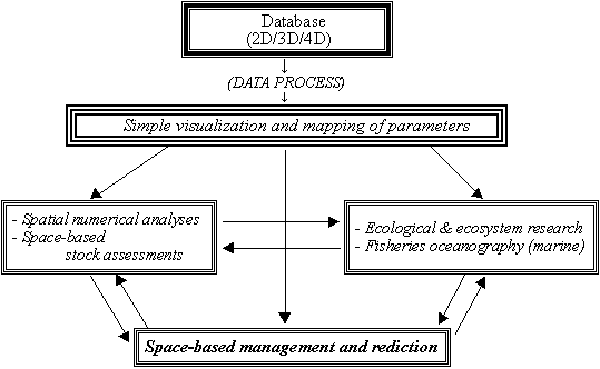
Detailed review of the 130 papers presented at the Symposium, and consideration of other relevant recently published papers, suggests that the application of GIS in fishery science might appropriately be categorized into four areas. These are:
| (a) | simple presentation of parameters in fishery science; |
| (b) | ecological/ecosystem research or fisheries oceanography in marine science; |
| (c) | spatial numerical analyses and space-based stock assessments; and |
| (d) | space-based management and predictions. |
Figure 1 shows their relationship. The four categories are often interrelated and overlap.
Å@
Å@
Figure 1.
Relationships among four categories of the application of GIS in
fishery science.
(Note: These four areas frequently overlap.)
Å@
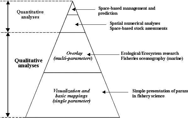
Further consideration suggests that the relative significance of these four categories can be summarized as shown in Figure 2. Most applications (more than 90%) are qualitative analyses (simple mapping and overlay in ecological research). This situation reflects the current situation for GIS application in fishery science.
Å@
 Å@
Å@
Figure 2. Summary of the current situation in GIS application in fishery science
Å@
Problems and improvements ...
The primary reason for qualitative than quantitative analyses is probably the nature of the terrestrial GIS software. The terrestrial GIS is probably rather inappropriate for tackling numerical and complicated spatial analyses for unique fishery information that exhibits marked differences from land-based information. As mentioned, 95% of the papers presented at the Symposium used terrestrial-based GIS software. In their papers, a number of the authors who conducted qualitative analyses discussed difficulties associated with immediate extension to quantitative applications using the current terrestrial-based GIS software. Several papers dealing with sophisticated and advanced numerical applications using terrestrial GIS software were presented but such elaboration was only feasible for skilled specialists.
In addition to the constraints associated with quantitative analyses, scope for the presentation of three- four- dimensional (3D-4D) information is also limited in the currently available terrestrial GIS software. This is, again, due to the difference in quality of information between fishery science and terrestrial science.
Under such circumstances, there is a need for more user-friendly and fishery-specific GIS software which is capable and effective for quantitative spatial analyses and presentations of 3D-4D fishery information. Development of such software will be one of the most challenging areas in fishery GIS application in the immediate future. In fact, some terrestrial GIS software firms have already started to expand their products' applicability to fishery GIS information. In addition, a few marine-specific GIS software products are under development, able to handle both qualitative and numerical spatial analyses for fishery and oceanographic information including 3D-4D data. If such new products are effectively developed and are really user-friendly, then it may be anticipated that there will be significant improvements in GIS application in fishery science for both quantitative and qualitative spatial analyses. As has been the case for terrestrial applications, progress in user-friendly software development can enable analyses to proceed without a requirement for the involvement of specialist GIS experts.
But, enjoy the GIS maps ...
Although we have pointed to many areas for future improvement in GIS applications in fishery science, you should nonetheless find value and enjoyment in the variety of GIS Maps and Figures presented in this Proceedings. They are excellent 'home-made' (or we should say 'office-made') and elaborate representations, prepared by zealous authors. They illustrate the international proverb "Seeing is believing" ÅEone GIS Map can tell us everything, much more effectively than thousands of words. A map corresponds to an international 'common language' and communication tool, so that anyone (even children!) can readily understand the information presented. Maps enable anyone to overcome the frustration of an 'illiteracy syndrome' that difficult words otherwise impose and so allow everyone to be more content.
Second symposium ...
We will soon circulate the announcement for the 'Second International Symposium on GIS in Fishery Science', to be held in 2002 (venue to be decided soon). In the three years since the First Symposium, I have no doubts that tremendous progress on GIS in fishery science will have been accomplished. Hence, we encourage you to participate in the second symposium, to present updates on research with GIS and on other GIS-related progress (such as software, computer systems, education and reviews).
Acknowledgements ...
We express our sincere appreciation to authors and co-authors for their cooperation and contributions. In the course of finalization of the Proceedings over the last two years, we bothered them many times in relation to peer reviews and editorial matters (even during the last two Christmas recesses for some authors). Sometimes we pushed very hard to ensure that deadlines were met. Contributors come from many areas of the world, and speak different languages. During the two years since the Symposium some have changed jobs, some have married and some have even given birth. Despite this, all were very patient and met our demanding requirements. We sincerely thank the 62 referees from 13 countries, and express our special appreciation to the two professional editors, Patricia J. Kailola (Australia) and Chuck E. Hollingworth (U.K.). Without the dedicated peer reviews and patient editorial work the Proceedings could not have been produced. Thank you all, once again.
Finally, we hope to see you all at the Second International Symposium in 2002.
Tom Nishida
(Editor-in-charge)
March, 2001
Over-looking deep-snow-capped Mt. Fuji,
Shimizu City, Shizuoka Prefecture, Japan
![]()